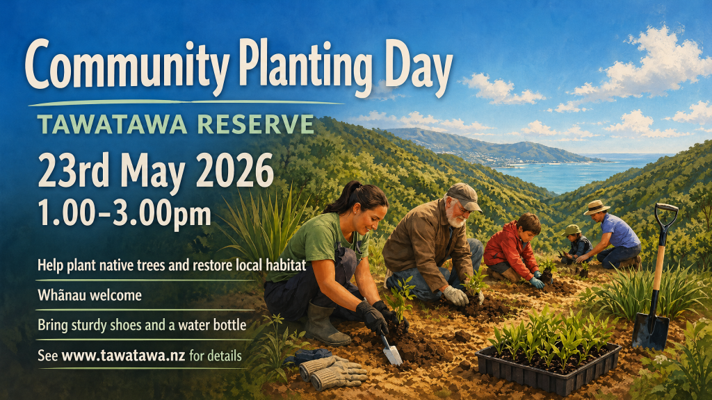
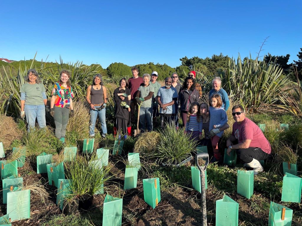
We are excited to host another Community Planting Day in the dog exercise area, a 2 minute walk from the Murchison Street car park. Just follow the paved road from the car park. Join us for a sausage sizzle once all the plants are in the ground! Tools and gloves provided, no experience necessary.
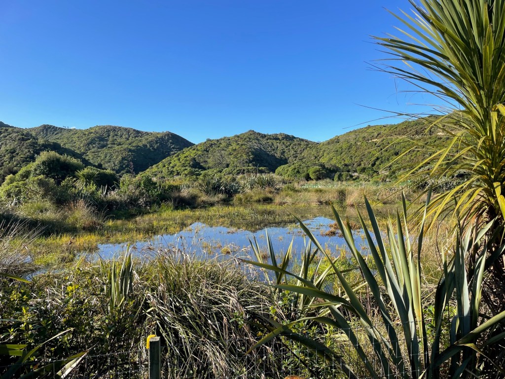
The lizard garden along the City to Sea Walkway began in 2019. It features native plants such as tī kouka (cabbage trees), wharariki (mountain flax), tauhinu (coastal tree daisy), mingimingi (twiggy coprosma), pohuehue (muehlenbeckia complexa), koromiko, and mānuka. Five years on, the plants are doing well, but one thing has been missing: basking areas! Reptiles are ectotherms, meaning they rely on external heat sources to maintain their body temperature. While needing external heat, typically sunlight, most of New Zealand’s skinks and geckoes prefer to bask cryptically or with only part of their body in direct sunlight. Rock piles create an ideal habitat where skinks and geckoes can be partially or fully concealed amidst the rocks while still absorbing heat as the sun warms the stones.
If you have been walking by the garden, you might have noticed a pile of rocks beginning to form. While we might call them rock piles, these structures do not only have to be made of rocks; they can include old bricks, broken pottery, chunks of concrete, and more, as long as they can be placed to make small crevices and hollows for lizards to hide away in. The rocks and other materials used at our lizard garden are being collected from places around the reserve.
Creating safe places for our native skinks and geckoes is vital as their numbers continue to decline. Creating a lizard garden in your backyard or neighbourhood park can help provide a habitat for lizards in urban environments. However, creating a suitable habitat for them is not the only measure needed to attract lizards to an area. Reducing or eradicating predator presence is equally as important. Most of our native skinks and geckoes do not have a defence against predators like rats, stoats, mice, and cats.
At Tawatawa Reserve, volunteers continue to participate in predator trapping, planting, and weeding to create a natural haven for wildlife and people amidst the hustle and bustle of town. Keep an eye out at the Lizard Garden to see how the rock piles grow and try to see what other materials might make their way into the structures!
The rock piles are being constructed by Kate, a Conservation Biology Master’s student studying at Victoria University Wellington.
With nearly a dozen little blue penguin/kororā deaths along Wellington’s coast in recent months due to dog attacks, and a dog walker hearing the call of a male kiwi near the water reservoir at Tawatawa, dog/avian interactions are now a hot topic. It is timely that kororā aversion training had been developed that follows the same principals as kiwi aversion training.
SEA Chairperson, Annie Yeates, took her trusty side kick Poppy the fox terrier along to a penguin aversion training (PAT) session, so she could observe the process first hand. Annie also checks the traps along the south coast between Island and Ōwhiro Bay on behalf of the Forest & Bird project Places for Penguins and knows first-hand how close the little kororā nest to the footpath, and how easily they can be attacked by dog even on a long lead.
The penguin avoidance training is organised by Ross Gilmor. Ross helped to create the course after falling in love with kororā after they started nesting underneath his house in Eastbourne. Ross was very impressed with the training methods used by Willy Marsh for Kiwi Aversion Training and together they created a similar course for penguins.
For the PAT, Willy had set up a training course along the beach/dunes close to Queens Drive, Lyall Bay. There were real ‘stuffed penguins’ (Willy has a special DOC licence for handling the birds), penguin boxes and even penguin poop! Willy uses a vibrating collar, and importantly does not shock the dogs. Poppy only needed the collar on for the first three penguins, Willy knew that she had ‘got it’ at that point and the collar was taken off, and Poppy completed the training course lead free, giving all penguins and penguin boxes a very wide birth! The penguin poop however was still irresistible and very nearly rolled in!
If you are keen to know more or book your dog on a penguin avoidance training course ($40), contact Ross on: ross@penguinavoidance.org
The next kiwi aversion courses being run by Willy are being held at the Catchpool Community Centre & Emergency Hub on the Wainui Coast Road on the 9 & 10th November. Email kat@remutaka.nz if you are keen to enrol.
If you dog has already done penguin avoidance training, they don’t need to wear the collar again for the kiwi training.
As we learn to live with more and more native taonga as their numbers recover through efforts such as predator control, it is important we take responsibility for not only our actions, but those of our pets. Native birds and lizards have a right to live safely, without predation from our dogs and cats.
Poppy & trainer Willy at the start of the penguin avoidance course.
Very realistic setting for the training. Some of the penguins are on strings, moving the birds as the dogs walk by.
It worked! Poppy taking the long way ’round to avoid the penguin (to the left of the picture).
2024 celebrates the 30th Anniversary of the Southern Environmental Association (SEA). Here are some of the highlights over the last three decades.
Lobbying for the Creation of Tawatawa Reserve (gazetted as a reserve in 2009)
Save our Skyline (SOS), lobbying for the ridgelines to be kept natural between Kingston and Ōwhiro Bay, opposing the development of 5 subdivisions along the ridgelines that is now Tawatawa Reserve
Advocating for the closure of the Ōwhiro Bay Quarry
Native tree nursery built to grow eco-sourced plants
Helping to create Paekawakawa Reserve
Creation of comprehensive Restoration Plan
Fencing-off of wetland to protect/increase invertebrate biodiversity 2019
Lizard garden planted 2020
Predator control implemented 2020
Development of Paekawakawa Link Track
Botanical signage installed around the reserve
SEA Tawatawa Givealittle page
SEA Tawatawa website
Founding member of Southern Wellington Weed Action Coalition (SWWAC)
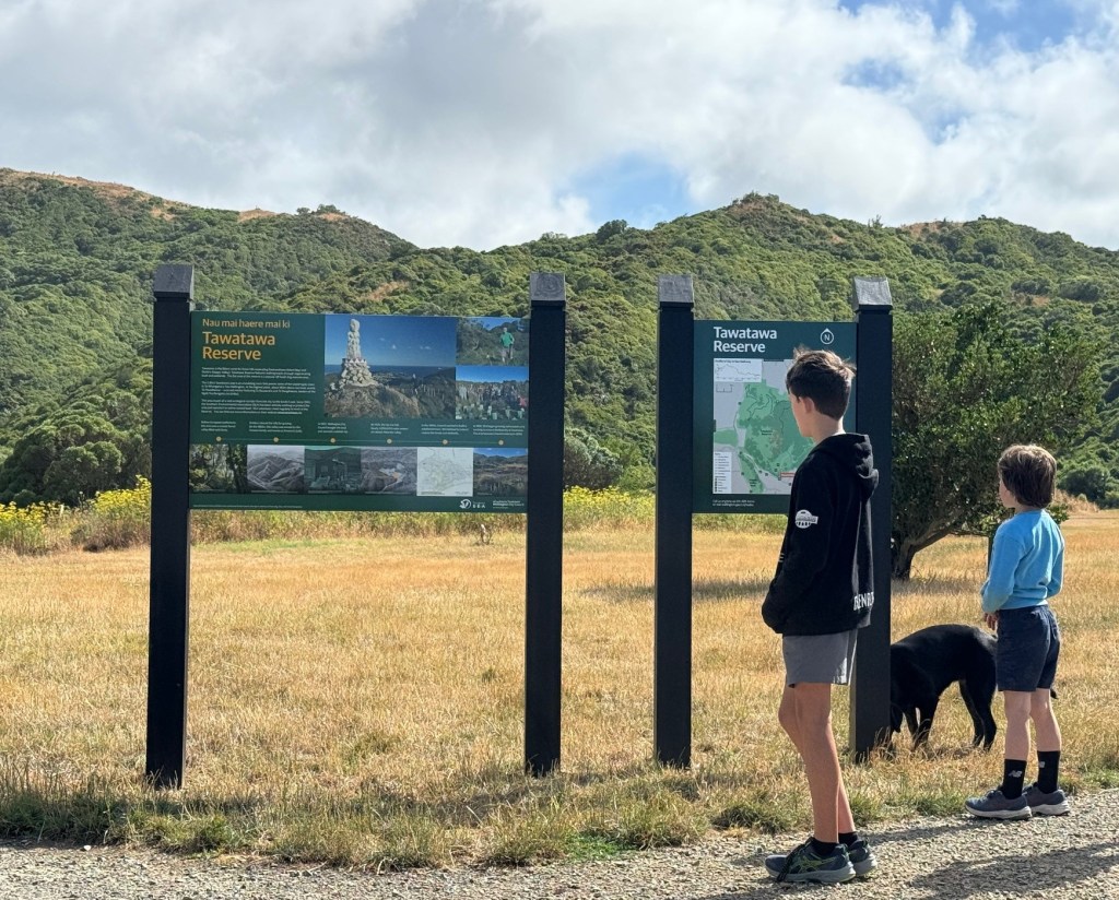
Tawatawa Reserve information sign and map boards
60,000 trees and shrubs planted in Tawatawa since 1992
750 mammalian pests trapped by SEA volunteers
1,600 volunteer hours per year
Founding SEA members opposing the Ōwhiro Bay Quarry.
Even a visit from renowned environmentalist David Bellamy (top right photo wearing yellow jacket)
Planned subdivisions along the ridgeline between Kingston and Ōwhiro Bay.
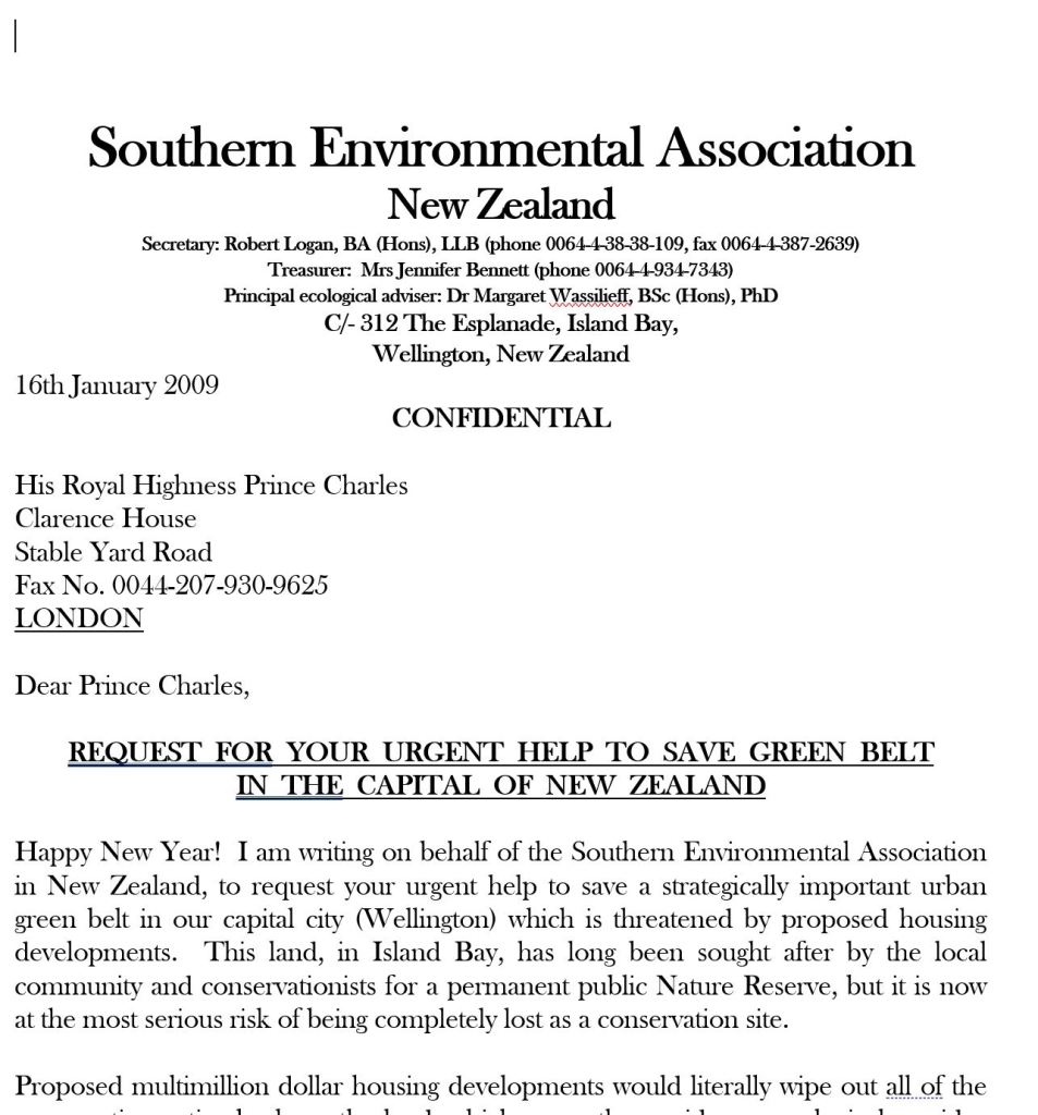
Requests for help went far and wide – this plea for help to Prince (now King) Charles.
Tawatawa Reserve circa 2003 from Irwell Street looking west. You can just see the wetland area beginning to form and pines on the western hills (Photo credit: Kathryn Hazelwood).
Wetland 2023 (looking north)
Pines on western hills removed after big storm of 2013 (Photo credit Marty Winkels)
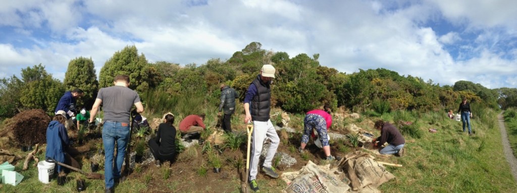
The Centre for Climate and Security (CCS), with support from the US Mission to New Zealand, launched the Youth-Led Visions of a Climate-Secure Pacific program, sending a cohort of young leaders to Aotearoa New Zealand to build toward a better future.
During their trip, the young leaders volunteered at Tawatawa Reserve alongside members of the Southern Environmental Association, planting native species to help preserve the region’s biodiversity. Equipped with shovels and gloves, they carefully placed young trees and shrubs in the soil along the ridgeline and cleared paths of weeds. As they worked, they learned about the ecological importance of these plants as well as the history of conservation and land management on the reserve.
The young leaders left the experience with a shared sense of accomplishment and camaraderie and were grateful to have the opportunity to contribute toward healing the land and combating the effects of climate change through direct action at the local level.
It was an honour to host the next generation of climate security leaders in the Pacific, and we wish them all the very best in their future climate security endeavours!
Ever wondered what happen when you purchased carbon credits for your flight’s emissions with Air New Zealand? They end up with projects such as ours at Tawatawa Reserve thanks to Trees That Count (TTC).
TTC fund SEA to plant 1,500 trees a year at Tawatawa. The money helps to pay the running costs of our native tree nursery, tools and equipment.
The TTC team rolled their sleeves up and came to Tawatawa in June 2024, helping to plant over 84 trees along the City to Sea Walkway.
The funding from TTC is a very valuable income stream to SEA, and we are very thankful to TTC and their supporters and donors for helping us continue the ecological restoration of Tawatawa Reserve.
Part 1 of this history of Tawatawa Reserve and the SEA was published in our newsletter of March 2022.
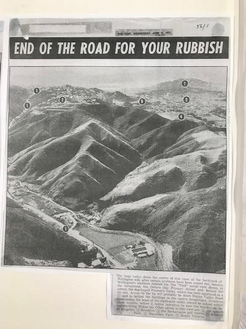
Following closure of Preston’s Gully tip in August 1976, the area was put to several uses including mini-bike riding, horse grazing, and in 1977, dumping of soil from the Terrace Tunnel project. For a decade much of the surrounding hillsides were covered in fennel, gorse and other weed species with a large stand of old pines on the western ridgeline. The Wellington City Council (the Council) owned part of the land with Preston’s Farms still owning the remainder.
In the early 1990s, the Council proposed using the eastern side of the hills for a residential subdivision, effectively joining Quebec Street and Frobisher Street along what is now the City to Sea walkway, with the flat area below to be turned into playing fields.
There was much public opposition to this plan and in 1992, the Southern Environmental Association (SEA) was formed, led by Wellington lawyer and environmentalist, Robert Logan. The case of those opposing subdivision was strengthened by the find of a 5-hectare remnant of coastal forest including a stand of (then) 70-year-old kanuka, a couple of mature kohekohe and some rare local natives such as wharangi at the northern end of the gully which had been protected by tall gorse and the steep terrain.
The SEA joined the tide of lobbying by a group calling itself ‘Save our Skyline’ and other groups and individuals against the proposed subdivision that was eventually successful in convincing the Council to work towards establishing a reserve rather than a subdivision. By 2006, the area was recognized as an informal reserve. The entire tip face was capped with clay to seal it and the flat area was extended, upgraded, and grassed to make it more attractive and usable.
However, Tawatawa Reserve’s use as a landfill was not quite over. Excavated rock and clay from the construction of the inner-city bypass (Karo Drive) in 2005/2006 were dumped at the northern end of the valley to form a bund with the intent of reducing surface water leaching through to the landfill by creating a small wetland at the north end of the valley in the resulting hollow. Despite some attempts in 2009 and subsequently to landscape this area it has proved difficult to create a wetland.
In 2010, Council named the area Tawatawa Reserve, and resolved to gazette the area as a scenic reserve. It was finally gazetted in November 2014.
The development of the SEA
As well as the successful campaign to create Tawatawa Reserve, the SEA, led by Robert Logan was very active in lobbying for environmental causes around Wellington and especially on the South Coast.
The SEA was registered as an incorporated society in June 1994 with the aim of protecting those parts of the Wellington environment that were under threat and warranted permanent protection for the benefit of the community. The Society’s objectives included protection and enhancement of the environment and heritage of Wellington particularly southern Wellington.
Working sometimes with other groups, its early achievements included:
closing the quarry operation located west of Ōwhiro Bay and creation of a public reserve (Te Kopahou Reserve);
persuading the council to give greater protection to the Waipapa Stream behind Red Rocks and Makara Stream;
laying the ground work for the creation of Long Gully Bush Reserve between Karori and Brooklyn;
lobbying for the elimination of water pollution and stream bed modification of Ōwhiro Stream;
establishing the flourishing native plant nursery that remains today in Tawatawa Reserve;
spearheading the campaign in 2006 to support a separate private trust to purchase a piece of land in the heart of Island Bay: another remnant of native bush that is now known as the Paekawakawa Reserve and which continues to be developed as a bush and bird reserve.
During 2008, the SEA reevaluated its activities and the organisation decided to narrow its focus to the restoration of the Tawatawa Reserve. In particular, the development of the on-site native plant nursery using eco-sourced seed to grow native trees and shrubs for planting in the Reserve – all 64 hectares of it.
Subsequently, the Council formalized its relationship with the SEA, granting an occupation license over the Reserve for the purpose of allowing the SEA to grow native plants in the nursery for regenerative plantings. This was one of the benefits of being an incorporated society. In 2012, the SEA was registered as a charitable trust.
When a storm in 2013 decimated a large stand of pines on the western ridge, the Council took the opportunity to remove them, along with others that remained standing. The ridge is now regenerating native bush.
The SEA’s vision was formalised in a comprehensive Restoration Plan in 2015. The aim of the plan remains that of creating a healthy native forest and wetland habitat supporting abundant and diverse native flora and fauna and providing a community asset that is valued by both local residents and visitors.
Some of the SEA’s more recent achievements have been:
entering into an agreement with Conservation Volunteers NZ (CVNZ) in 2016 to share the nursery space and provide mutual assistance with environmental projects.
Developing the natural drainage area that formed early on near to where the nursery is now. The current wetland area was fenced in late 2018 after a project by a Victoria University Masters student showed that invertebrate and plant life would flourish if it was fenced off from humans and dogs. So it has proved with frogs, other invertebrates and many birds now frequenting it.
Building relationships with neighbouring reserves with a view to developing a unified strategy for weed and pest control.
In the 30 years between 1992 and 2022, an estimated 50,000 native trees have been planted in the reserve by way of an average of 1600 volunteer hours each year.
Creation of a Lizard Garden on adjeacent to the City to Sea Walkway
Creation of the Link Track, linking the green spaces of Tawatawa Reserve, Manawa Karioi and Paekawakawa to the heart of Island Bay.
Implementing a comprehensive predator control programme.
The SEA is still run by volunteers in partnership with the Wellington City Council and with help from volunteer corporate groups, dog walkers and other members of the community.
Join us for a community planting day at Tawatawa Reserve on Saturday 3rd August 1.00pm to 3.00pm. We’ll be planting near the middle of the off-leash dog exercise area, a 2 minute walk from the Murchison Street car park!
There will be a sausage sizzle and refreshments to end the day.
If you have them, please bring: sturdy footwear or gumboots, gardening gloves and spades or shovels.
Keep an eye on our Facebook page for weather updates.
Imagine Tawatawa Reserve before the arrival of humans. The 64 hectares of coastal hills and steep valley above what is now Ōwhiro Bay, were thought to have supported a coastal podocarp/broadleaf forest.
A stream meandered down the deep valley joining with what is now the Ōwhiro Stream below. The forest is likely to have supported much bird and insect life. Very few remnants of this forest type are left in the Wellington region however the existing remnants at Ōtari are believed to be similar to the forests that would have grown around the Tawatawa hills.
According to an article in the Evening Post (1) Tawatawa, meaning mackerel, was the name of the range extending from Brooklyn to the sea on the western side of Island Bay. It took its name from a fishing pā which used to stand at the extremity of the ridge above what is now Beach Street, Tyne Street and Knoll Street on the Island Bay coast.
As far as we know today, there appear to have been no pā sites in what is now the reserve, but the land around Te Pouwhenua on the northern skyline, is said to be a former Māori urupā (burial ground). Te Pouwhenau stands at the highest point in the reserve. It bears the faces of Te Rauparaha and his nephew Te Rangihaeata. It was erected in 1979 by members of Tapu Te Ranga Marae.
Early European settlers cleared the land and attempted to farm it, however the poor soils and steep hills proved unsuitable for farming and the land may well have been unused for some time, allowing some forest to grow back on the ridges and gullies: seedlings from the forest that had been cleared.
In the 1960s, the valley and the land west of the ridge going down to Happy Valley Road was owned by the Preston family, some of it being farmed and other areas on Happy Valley Road being used for light industrial businesses.
A memo dated 15 April 1960 from the City Engineer to the Wellington City Council (2) warned the Council that the City’s Houghton Bay refuse tip was nearly full and another site was needed in South Wellington. The ‘gully’ on land owned by the Preston family was a possible site. A ‘Bradford tip’ was proposed, a design that made use of an existing depression or gully, one of twenty seven that were developed in Wellington up to 1970.
Negotiations between the Council and the Preston family to purchase the gully took twelve years, with disputes over the zoning of the land, its financial value, the Preston family’s concerns that its acquisition would constrain further development over the rest of their land and in the context of strong public opposition to the proposal (3). The Council finally acquired 150 acres of Preston land for $158,000.
Tawatawa Reserve was briefly a rubbish tip, from 1973 to 1976.
Construction work started in late 1972 with a bund (earth wall) created by extensively cutting the south facing hill overlooking Happy Valley Road. This provided most of the material for the bund fill and the adjacent development of playing fields. Construction of the tip access road included straightening Happy Valley Road so the access road formed a T-intersection and diversion of Ōwhiro Stream to the east along the foot of the hill. It is difficult to align the original hill profile with what exists now. However, it appears that the tip access road (and subsequently Murchison Street that was formed in 1990), were constructed along the top of the bund to allow access to the hidden tip in Preston’s Gully.
The tip was opened in June 1973. It was originally expected to last 15 years, but was closed in August 1976. Early estimates that it would create 16.5 acres of level land were reduced to 8 acres. Nonetheless over one million cubic meters of household and industrial waste were buried in what was known as Preston’s Gully. The tip operation created the inevitable inconveniences to local residents of smell, windblown rubbish and leachate (4).
Following closure of Preston’s Gully tip, the area was put to several uses including minibike riding and horse grazing. Soil from the Terrace Tunnel project was also dumped in the Gully in 1977 (5). For a decade much of the surrounding hillsides were covered in fennel and gorse and other weed species, with a large stand of old pines on the western ridgeline. What had not yet been found was an approximate 5 hectare stand of relatively pristine coastal forest. The area located at the northern end of the valley above the tip was protected by gorse and steep terrain: this hidden jewel was to prove critical in the subsequent development of Preston’s Gully.
Notes: 1: “Old Wellington” Evening Post VOL lxxxiii, Issue 136 8 June 1912; 2: From information compiled by Marion Findlay held in the archives of the Island Bay Historical Society; 3: Ibid; 4: Ibid; 5: Ibid.
Next time: Preston’s Gully becomes Tawatawa Reserve.
Predator Free Wellington (PFW) are working on the second phase of their eradication project, which will soon involve Tawatawa and other conservation projects on the South Coast.
Whilst much of the activity is focused on the properties in Roseneath and Hataitai at present, PFW will begin to set up the next ‘barrier’ as close to the start of the eradication project as possible, to minimise reinvasion during the eradication process.
The barrier will run through Mt Cook and follows the green belt through the bottom of Prince of Wales park, over Tawatawa Reserve, Manawa Karioi, Paekawakawa Reserve and into Ōwhiro Bay.
The barrier will aim to minimise incursions of predator species into the eradication area to near zero from the west including Te Kopahou Reserve and the Southern Landfill.
A fence can’t be erected to protect the area from reinvasion like at Zealandia, so PFW are developing a plan to create an intensive barrier of bait stations and traps.
The barrier presents an exciting opportunity for community trapping groups to be directly involved in a large-scale eradication project, and protect the city from predator species incursions. Volunteers will gain skills and experience in pest species monitoring, line cutting, and different eradication methods.
We’ll be looking for volunteers to be part of the project – helping to install and service the devices and feed back data to the eradication project. The model created with this project is likely to be replicated throughout New Zealand and supports the Predator Free 2050 goal.
The plan is in development and is likely to begin being rolled out in late summer/early autumn.
Jenny Kilpatrick has kindly offered to help coordinate barrier activities for Tawatawa. Jenny has been involved with trapping around the reserve since we started last year and is now keen to step up to help implement new Stage 2 barrier. Here is a little about Jenny:
I’m Jenny Kilpatrick and I have lived in Island Bay with Tony since 2012. Our 2 dogs Smitty and Java joined us a couple of years later. We are walking in some part of the Tawatawa Reserve, Manawa Karioi Restoration Project, Paekawakawa Reserve or the Oku Reserve every day. It’s been a joy over that time to see the plantings mature and to see and hear the increase in birdlife. Smitty and I signed up early on to clear one of the Tawatawa traplines and then one of the Manawa Karioi traplines.
I am also a tramper and am always sad when the bush is quiet. Just recently, I was in the Mt Arthur/Tablelands area and was very impressed with the intensive trapping that The Friends of Flora do. The Wellington Predator Free team have learned a lot from their work on the Miramar peninsula, and I am excited to be able to help put in practice what they have learned and be part of the next stage of helping Wellington to become pest free.
If you would like to know more about becoming a Community Ranger, Jenny can be contacted on jenny@portablepanic.co.nz or 022 045 7340