Imagine Tawatawa Reserve before the arrival of humans. The 64 hectares of coastal hills and steep valley above what is now Ōwhiro Bay, were thought to have supported a coastal podocarp/broadleaf forest.
A stream meandered down the deep valley joining with what is now the Ōwhiro Stream below. The forest is likely to have supported much bird and insect life. Very few remnants of this forest type are left in the Wellington region however the existing remnants at Ōtari are believed to be similar to the forests that would have grown around the Tawatawa hills.
According to an article in the Evening Post (1) Tawatawa, meaning mackerel, was the name of the range extending from Brooklyn to the sea on the western side of Island Bay. It took its name from a fishing pā which used to stand at the extremity of the ridge above what is now Beach Street, Tyne Street and Knoll Street on the Island Bay coast.
As far as we know today, there appear to have been no pā sites in what is now the reserve, but the land around Te Pouwhenua on the northern skyline, is said to be a former Māori urupā (burial ground). Te Pouwhenau stands at the highest point in the reserve. It bears the faces of Te Rauparaha and his nephew Te Rangihaeata. It was erected in 1979 by members of Tapu Te Ranga Marae.
Early European settlers cleared the land and attempted to farm it, however the poor soils and steep hills proved unsuitable for farming and the land may well have been unused for some time, allowing some forest to grow back on the ridges and gullies: seedlings from the forest that had been cleared.
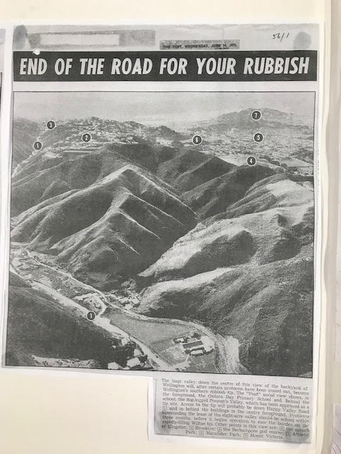
In the 1960s, the valley and the land west of the ridge going down to Happy Valley Road was owned by the Preston family, some of it being farmed and other areas on Happy Valley Road being used for light industrial businesses.
A memo dated 15 April 1960 from the City Engineer to the Wellington City Council (2) warned the Council that the City’s Houghton Bay refuse tip was nearly full and another site was needed in South Wellington. The ‘gully’ on land owned by the Preston family was a possible site. A ‘Bradford tip’ was proposed, a design that made use of an existing depression or gully, one of twenty seven that were developed in Wellington up to 1970.
Negotiations between the Council and the Preston family to purchase the gully took twelve years, with disputes over the zoning of the land, its financial value, the Preston family’s concerns that its acquisition would constrain further development over the rest of their land and in the context of strong public opposition to the proposal (3). The Council finally acquired 150 acres of Preston land for $158,000.
Construction work started in late 1972 with a bund (earth wall) created by extensively cutting the south facing hill overlooking Happy Valley Road. This provided most of the material for the bund fill and the adjacent development of playing fields. Construction of the tip access road included straightening Happy Valley Road so the access road formed a T-intersection and diversion of Ōwhiro Stream to the east along the foot of the hill. It is difficult to align the original hill profile with what exists now. However, it appears that the tip access road (and subsequently Murchison Street that was formed in 1990), were constructed along the top of the bund to allow access to the hidden tip in Preston’s Gully.
The tip was opened in June 1973. It was originally expected to last 15 years, but was closed in August 1976. Early estimates that it would create 16.5 acres of level land were reduced to 8 acres. Nonetheless over one million cubic meters of household and industrial waste were buried in what was known as Preston’s Gully. The tip operation created the inevitable inconveniences to local residents of smell, windblown rubbish and leachate (4).
Following closure of Preston’s Gully tip, the area was put to several uses including minibike riding and horse grazing. Soil from the Terrace Tunnel project was also dumped in the Gully in 1977 (5). For a decade much of the surrounding hillsides were covered in fennel and gorse and other weed species, with a large stand of old pines on the western ridgeline. What had not yet been found was an approximate 5 hectare stand of relatively pristine coastal forest. The area located at the northern end of the valley above the tip was protected by gorse and steep terrain: this hidden jewel was to prove critical in the subsequent development of Preston’s Gully.
Notes: 1: “Old Wellington” Evening Post VOL lxxxiii, Issue 136 8 June 1912; 2: From information compiled by Marion Findlay held in the archives of the Island Bay Historical Society; 3: Ibid; 4: Ibid; 5: Ibid.
Next time: Preston’s Gully becomes Tawatawa Reserve.
